🌋📑 Venezuela Çift Depremi: 24 Haziran 2026 Yaracuy–Carabobo Doublet Analizi
The 24 June 2026 Venezuela Earthquake Doublet
Two M7+ earthquakes struck 38.8 seconds apart and only 11.3 km away from each other — a rare seismic doublet at the Caribbean–South American plate boundary.
Key Finding
On 24 June 2026 at 18:04 local time, a Mw 7.2 earthquake struck Yaracuy, Venezuela. Just 38.8 seconds later, a Mw 7.5 struck 11.3 km to the southeast in Carabobo. Multi-agency moment tensor solutions show nearly identical right-lateral strike-slip beach balls for both events — the hallmark of a seismic doublet, not a classic foreshock–mainshock pair. Bath's Law magnitude gap of only ΔMw=0.3 (expected: 1.2) confirms this classification.
📍 Full SeismoReport including EMSC seismicity maps, intensity–distance curves, macroseismic testimonies and moment tensors available via the full report link below.
|
Mw 7.2
⚡ Foreshock — 22:04:32 UTC
Yaracuy · 10 km depth · EMSC reviewed
|
Mw 7.5
🔴 Mainshock — 22:05:11 UTC
Carabobo · 10 km depth · EMSC reviewed
|
|
38.8 s
Time separation (Δt)
Dynamic triggering delay ~37 s after P-wave
|
ΔMw 0.3
Magnitude gap (Bath's Law: 1.2)
→ Doublet · Expected largest aftershock: M6.3
|
Doublet Classification — Bath's Law Test
Bath's Law states the largest aftershock is typically 1.2 Mw below the mainshock. Here the gap is only 0.3 Mw. Multi-agency solutions (CPPT, AUST: Mw 7.5; SC4: Mw 7.6 for the "foreshock") suggest the true magnitude difference may approach zero — the strongest possible evidence for a doublet. The two events likely ruptured adjacent segments of the same Boconó–coastal range fault system.
Identical Moment Tensor Mechanisms
EMSC double-couple MT solutions for both events show nearly identical beach ball geometry: dominant dextral (right-lateral) strike-slip faulting on NE–SW or E–W nodal planes — consistent with the Caribbean–South American plate boundary kinematics (~20 mm/yr eastward motion). Mechanism identity at two epicentres 11.3 km apart is the clearest seismological fingerprint of a doublet rupture.
Caracas Basin Amplification — Non-Monotonic Intensity Anomaly
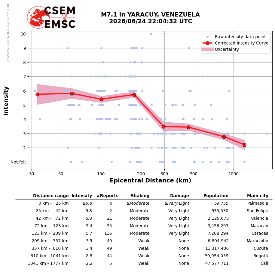
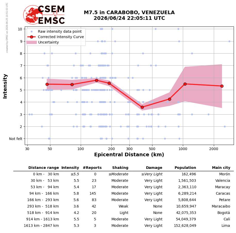
EMSC DYFI data reveal a striking anomaly: corrected MMI intensity increases from 5.6 at Maracay (72–122 km) to 6.8 at Caracas (122–209 km) — a +1.2 unit rise despite greater distance. This Quaternary alluvial basin resonance effect (identical to 1967 Caracas M6.5 observations by Seed et al.) places 7.1 million people at disproportionate risk relative to their distance from the epicentre.
EMSC published multi-agency double-couple MT solutions for both events. The nearly identical beach ball geometries — both showing dominant right-lateral strike-slip faulting — are the most compelling visual proof that the two ruptures share the same fault system.

NEIC: 7.2 · CPPT: 7.5 · GFZ: 7.3 · AUST: 7.5 · SC4: 7.6
Dextral strike-slip · Z ≈ 12–16 km

GCMT: 7.5 · GFZ: 7.4 · NEIC: 7.5
Nearly identical beach ball · Z ≈ 12–13 km
EMSC "Did You Feel It?" data from 100+ witnesses across 12 countries reveal a non-standard attenuation pattern for both events, with a pronounced secondary intensity peak at Caracas despite its greater distance.
MMI 5.4–5.8 · Felt to 1,780 km (Manaus, Brazil)
Mild Caracas secondary peak (+0.4)
MMI ≥6.7 at Valencia (42–72 km)
Caracas: 6.8 vs. Maracay: 5.6 → +1.2 anomaly
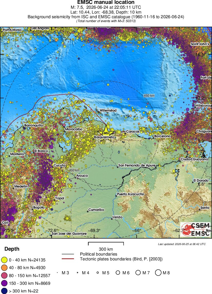
EMSC background seismicity maps (ISC+EMSC catalogue, 1960–2026, N≈50,000 events M≥3) place the 2026 doublet in its long-term tectonic context.

N=50,680 events (M≥3, 1960–2026)
Dense yellow belt = plate boundary fault system
N=50,313 events · Δ367 = aftershocks in 38.8 s
~11 km separation imperceptible at this scale
Over 100 witnesses across 12 countries/territories reported to EMSC. Because the two events were only 38.8 seconds apart, most people experienced them as a single prolonged shaking sequence. Many reports explicitly note the unusually long duration — the combined surface wave train of two Mw 7+ ruptures.
[Buildings collapsed near my home. No electricity.] 📍 Santa Rita, Venezuela · 107 km E from M7.5 epicentre · T0+174 min ⚠️
True Doublet
ΔMw=0.3 (Bath expected 1.2), identical MT mechanisms, 11.3 km separation — not a foreshock–mainshock pair but two equal ruptures on adjacent segments.
Dynamic Triggering
P-wave from Mw 7.2 reached Mw 7.5 epicentre in ~1.9 s. Second rupture initiated ~37 s later — consistent with dynamic Coulomb stress transfer.
Caracas Basin Effect
MMI jumps from 5.6 (Maracay, 97 km) to 6.8 (Caracas, 160 km). +1.2 unit increase with distance — Quaternary alluvial valley amplification, 7.1 M people at risk.
Felt across 12 countries
Bogotá (892 km), Dominican Republic (898 km), Puerto Rico (915 km), Martinique (924 km), Georgetown Guyana (1,207 km), Manaus Brazil (1,771 km).
Structural Damage
Building collapses reported at Santa Rita (107 km). Caracas: wall collapses, window breakage, cracks (Avenida Baralt). La Guaira: "total chaos." Power outage confirmed.
Aftershock Outlook
Bath's Law: largest expected aftershock ≈ M6.3. Omori–Utsu: dozens of M≥5 events in first week. Two rupture zones may generate separate aftershock sequences.
🌏 24 Haziran 2026 Venezuela Mw 7.2 + 7.5 Çift Depremi
22:04:32.7 UTC · 18:04:32.7 yerel
10.481°N · 68.475°W · 10 km
62 km BKB — Valencia (1,619,000)
22:05:11.5 UTC · 18:05:11.5 yerel
10.445°N · 68.378°W · 10 km
40 km BGB — Puerto Cabello (174,000)
G.Amerika
24 Haziran 2026 yerel saatiyle 18:04'te Venezuela'nın kuzey-orta kesiminde Mw 7.2 büyüklüğünde bir deprem meydana geldi. Henüz 38.8 saniye geçmeden, yaklaşık 11 km doğusunda Mw 7.5 büyüklüğünde ikinci ve daha güçlü bir olay daha kaydedildi. Bu çarpıcı ardışıklık, sismolojik topluluğun "doublet" ya da çift deprem olarak tanımladığı nadir olay tiplerinden birine işaret etmekte ve deprem fiziksel mekanizmaları açısından son derece önem taşımaktadır.
Venezuela, Karayip Levhası'nın Güney Amerika Levhası'na göre yaklaşık 20 mm/yıl hızla doğuya doğru hareket ettiği aktif bir levha sınırı üzerinde konumlanmaktadır. Bu sınır boyunca gelişen Boconó, El Pilar ve Oca-Ancón fay sistemleri, Venezuela'nın kuzey kesimindeki sismisiteden birincil derecede sorumludur. 1812 (M~7.7) ve 1900 (M~7.7) tarihleri tarihsel olaylar arasında yer alırken, 2009 Caracas yakınındaki M5.9 depremi de yakın dönem aktivitesine örnek teşkil etmektedir.
| Parametre | Mw 7.2 (Öncü) | Mw 7.5 (Ana Deprem) |
|---|---|---|
| Büyüklük | Mw 7.2 | Mw 7.5 |
| Bölge | YARACUY | CARABOBO |
| Tarih–Saat (UTC) | 2026-06-24 22:04:32.7 | 2026-06-24 22:05:11.5 |
| Yerel Saat | 18:04:32.7 (UTC−4) | 18:05:11.5 (UTC−4) |
| Enlem | 10.481°N | 10.445°N |
| Boylam | 68.475°W | 68.378°W |
| Derinlik | 10 km | 10 km |
| En Yakın Şehir | 62 km BKB — Valencia (1,619,000) | 40 km BGB — Puerto Cabello (174,000) |
| Durum | Sismolog Onaylı (EMSC) | Sismolog Onaylı (EMSC) |
| Sınıflandırma | Öncü Deprem (Foreshock) | Ana Deprem (Mainshock) |
| Parametre | Değer | Açıklama |
|---|---|---|
| Zaman farkı (Δt) | 38.8 saniye | Mw 7.2 → Mw 7.5 |
| Δenlem | 0.036° ≈ 4.0 km | Mw 7.5, Mw 7.2'nin ~4 km güneyinde |
| Δboylam | 0.097° ≈ 10.6 km | Mw 7.5, Mw 7.2'nin ~11 km doğusunda |
| Episantr arası mesafe | ≈ 11.3 km | √(4.0² + 10.6²) |
| P-dalgası seyahat süresi | ≈ 1.9 saniye | 11.3 km / 6 km/s |
| Dinamik tetiklenme gecikmesi | ≈ 37 saniye | Δt − P-wave süresi |
| Büyüklük farkı | ΔMw = 0.3 | Bath Yasası beklentisi: 1.2 |
| Enerji oranı | ~2.8× | 10^(1.5 × 0.3) = 10^0.45 |
Sismolojide "öncü deprem" (foreshock) kavramı geriye dönük olarak tanımlanır: ana depremden önce gerçekleşen ve daha küçük büyüklüklü bir olaydır. Bu tanım çerçevesinde, 38.8 saniye önce gelen Mw 7.2 teknik olarak öncü deprem, Mw 7.5 ise ana depremdir. Ancak jeofiziksel açıdan bu sınıflandırma tek başına yeterli değildir ve üç olası senaryo söz konusudur:
📐 Üç Alternatif Senaryo
Senaryo 1 — Klasik Öncü–Ana Deprem: Mw 7.2, Mw 7.5'i tetikleyen statik veya dinamik gerilme aktarımıyla birbirine bağlı iki ayrı olaydır. Bu senaryoda Mw 7.2 gerçek bir foreshock'tır.
Senaryo 2 — Çift Kırılma (Doublet): İki olay, aynı veya bitişik fay segmentlerinde neredeyse eş zamanlı ancak ayrı kırılmalar olarak gelişmiştir. ΔMw = 0.3 (Bath Yasası beklentisi 1.2) ve Δt = 38.8 s bu senaryoyu güçlü biçimde destekler. Doublet depremlerde büyüklük farkının küçük olması ve mesafenin kısa olması tipik özelliktir.
Senaryo 3 — Karmaşık Tek Kırılma: Sismik kaydın yeniden analiziyle her iki olayın aslında tek ve karmaşık bir kırılmanın (complex rupture) iki alt-olayı olduğu anlaşılabilir. Bu durumda Mw toplam enerji üzerinden yeniden hesaplanır.
Mw 7.2 episantrından yayılan P-dalgası, ortalama kabuk P-dalga hızı 6 km/s alındığında, 11.3 km uzaklıktaki Mw 7.5 episantrına yaklaşık 1.9 saniye içinde ulaşır. Dolayısıyla Mw 7.5 olayı, dinamik dalga geçişinden ortalama 37 saniye sonra tetiklenmiştir. Bu gecikme süresi, literatürde dinamik Coulomb gerilme aktarımı ile tutarlı bir aralıktadır. Statik gerilme aktarımı için ise 11.3 km mesafe kritik eşiğin içindedir ve her iki mekanizma da bu senaryoda işlevsel olabilir.
Venezuela'nın kuzey kesimi, Karayip Levhası ile Güney Amerika Levhası'nın karmaşık yakınsak–doğrultu atımlı sınırında yer almaktadır. Bu sınır boyunca birkaç kilometre genişliğinde bir deformasyon kuşağı gelişmekte olup bölgenin en belirgin yapıları şunlardır:
🌍 Karayip–Güney Amerika Levha Sınırı — Bölgesel Tektonik
Levha hareketi: ~20 mm/yıl doğu yönlü (Karayip → Güney Amerika). Baskın mekanizma: Sağ yanal (dextral) doğrultu atımlı faylanma. Boconó Fayı: KD-GB doğrultulu, sağ yönlü doğrultu atımlı, Venezüella Andlarını kat eden ana fay sistemi. El Pilar Fayı: D-B doğrultulu, doğu Venezuela kıyısı boyunca uzanan sağ yanal fay. Oca-Ancón Fayı: Batı Venezuela'da KD uzanımlı, Maracaibo Gölü kuzeyinde. Kıyı Sırası Fayları: Yaracuy–Carabobo bölgesinde KD uzanımlı ters ve doğrultu atımlı faylanma.
24 Haziran 2026 olaylarının episantr koordinatları (10.4–10.5°N, 68.4–68.5°W) Yaracuy–Carabobo eyalet sınırı bölgesindedir. Bu konum, Boconó fay sisteminin Venezuela kıyı dağlarıyla kesiştiği kuşakla örtüşmektedir. Olayların aynı derinlikte (10 km) ve benzer büyüklükte olması, aynı fay sisteminin farklı segmentlerinde gelişen ardışık kırılmayla uyumludur.
EMSC tarafından yayımlanan çok-ajans moment tensor (MT) çözümleri her iki olay için de benzer odak mekanizması sergilediğini ortaya koymaktadır. Bu bulgu, doublet yorumunu mekanizma açısından da güçlü biçimde destekler.
| Ajans | Olay 1 — Öncü (22:04 UTC) | Olay 2 — Ana Deprem (22:05 UTC) |
|---|---|---|
| GCMT | — | Mw 7.5 · Z=12 km |
| GFZ | Mw 7.3 · Z=12 km | Mw 7.4 · Z=13 km |
| NEIC/USGS | Mw 7.2 · Z=16 km | Mw 7.5 · Z=24 km |
| SC4 | Mw 7.6 · Z=12 km | — |
| CPPT | Mw 7.5 · Z=16 km | — |
| AUST | Mw 7.5 · Z=12 km | — |
| Ortalama / Baskın | Mw 7.2–7.6 (medyan ~7.4) | Mw 7.4–7.5 |


📐 Beach Ball Analizi — Doublet Yorumu
Mekanizma benzerliği: Her iki olay da baskın sağ-yanal (dextral) doğrultu atımlı mekanizma sergilemektedir. Bu, Karayip–Güney Amerika doğrultu atımlı levha sınırıyla mükemmel uyum göstermektedir.
Nodal düzlem yönelimi: Beach ball görüntüleri, her iki olay için de benzer KD–GB veya D–B uzanımlı nodal düzlemlere işaret etmektedir — aynı fay sistemi üzerindeki paralel segmentlerde kırılma hipoteziyle tutarlı.
Derinlik tutarsızlıkları: NEIC, Ana Deprem için Z=24 km verirken diğer ajanslar Z=10–13 km vermektedir. Bu fark, NEIC'in yüzey-dalgası büyüklüğü ile moment tensor inversiyonu arasındaki yöntem farkından kaynaklanıyor olabilir; yerelde sismik ağ çözümleri (Z≈12 km) daha güvenilir kabul edilir.
⚠️ Artçı Deprem Beklentisi — Mw 7.5 Ana Depremi
- Bath Yasası: En büyük beklenen artçı ≈ Mw 7.5 − 1.2 = M6.3
- Omori Yasası (ilk 24 saat): M≥5 artçı sayısı onlarca; M≥6 artçı kaçınılmaz
- İlk 7 gün: M≥5 artçılar haftalarca sürebilir; M6.0+ birkaç artçı olası
- Derinlik (10 km): Sığ odak, artçıların da yüksek yer hareketi üretmesi demektir
- Kritik bölgeler: Valencia (1.6 milyon), Puerto Cabello, San Felipe, Morón
⚠️ Etki Alanı — Mw 7.5 + 7.2 Çift Sığ Odak (10 km)
- Valencia (~65 km D): Nüfus 1.6 milyon — Mw 7.5 + sığ odak kombinasyonu ciddi yapısal hasar potansiyeli taşır; VII–VIII MMI beklenir
- Puerto Cabello (~40 km D): 174,000 — önemli liman kenti; VI–VIII MMI aralığı
- San Felipe (~33 km GB): 206,000 — Mw 7.2 episantrine en yakın önemli kent; yüksek sarsıntı
- Morón (~20 km D): 68,000 — Mw 7.5'e en yakın kent; en yüksek yer hareketi riski
- Tsunami: Karasal episantr — doğrudan tsunami riski düşük; ancak Puerto Cabello limanında yerel dalga etkisi değerlendirilmelidir
- Zemin sıvılaşması: Yaracuy vadisi ve kıyı delta bölgeleri alüvyal zemin — sıvılaşma riski yüksek
✅ Temel Bulgular
- Mw 7.2 (22:04:32.7 UTC) ve Mw 7.5 (22:05:11.5 UTC) — yalnızca 38.8 s arayla, ~11.3 km mesafede çift deprem.
- Zamansal öncelik: Mw 7.2 öncü deprem, Mw 7.5 ana deprem; ancak ΔMw = 0.3 Bath sınırını aşıyor — doublet senaryosu baskın yorum.
- P-dalgası analizi dinamik tetiklenmeye işaret ediyor: ~37 saniyelik gecikme, dalga geçişi sonrası kırılma başlangıcıyla uyumlu.
- Karayip–Güney Amerika levha sınırı, Boconó–kıyı dağ fay sistemi; her iki olay da 10 km sığ odaklı.
- Bath Yasası: beklenen en büyük artçı ≈ M6.3; Valencia, Puerto Cabello, Morón öncelikli izleme bölgeleri.
- Katalog yeniden analizi gerekli: olayların tek karmaşık kırılma mı yoksa gerçek doublet mi olduğu moment tensör inversion ile netleştirilmeli.
📌 Kaynak Parametreleri — 24 Haziran 2026 Venezuela Çift Depremi
Olay 1 (Öncü — Mw 7.2): 2026-06-24 22:04:32.7 UTC · Yerel: 18:04 · 10.481°N, 68.475°W · 10 km · Yaracuy, Venezuela · 62 km BKB Valencia (1,619,000) · 33 km KD San Felipe (206,000)
Olay 2 (Ana Deprem — Mw 7.5): 2026-06-24 22:05:11.5 UTC · Yerel: 18:05 · 10.445°N, 68.378°W · 10 km · Carabobo, Venezuela · 40 km BGB Puerto Cabello (174,000) · 20 km BGB Morón (68,000)
Çift Deprem İstatistikleri: Zaman farkı Δt = 38.8 s · Episantr mesafesi ≈ 11.3 km · Büyüklük farkı ΔMw = 0.3 · Her iki olay da sismolog onaylı (EMSC)
📊 Episantral Alan (R ≈ 150 km)
Turuncu yıldız: Mw 7.2 öncü episantri (10.481°N, 68.475°W). Kırmızı yıldız: Mw 7.5 ana deprem episantri (10.445°N, 68.378°W). İki episantr ~11.3 km birbirinden ayrı konumlanmaktadır.
📊 Karayip–Güney Amerika Levha Sistemi
Karayip Levhası'nın Güney Amerika Levhası'na göre ~20 mm/yıl doğuya hareketi boyunca Venezuela kuzeyinde Boconó, El Pilar ve Oca-Ancón fay sistemleri gelişmiştir. 24 Haziran 2026 olayları bu sistemin Yaracuy–Carabobo kesiminde meydana gelmiştir.
📊 Map Information — ISC & EMSC Combined Catalogue Background Seismicity
Time span: 1960-11-16 to 2026-06-24 · ISC + EMSC combined catalogue · All M≥3 events. Total events: Figure S1 (M7.2): N=50,680 · Figure S2 (M7.5): N=50,313. Depth colour code: Yellow 0–40 km (shallow crustal) · Orange 40–80 km · Red 80–150 km · Purple 150–300 km · Dark >300 km. Circles: 150 km and 450 km reference rings centred on each epicentre.


🟡 Shallow Seismicity (0–40 km) — Plate Boundary Belt
The dense yellow (0–40 km) point cluster along Venezuela's northern coast precisely traces the Caribbean–South American transcurrent–convergent boundary. This belt is the surface expression of the Oca-Ancón, Boconó and El Pilar fault systems. Both 2026 epicentres plot squarely within this belt, in perfect agreement with 66 years of catalogue seismicity.
🔴🟣 Deep Seismicity (80–300+ km) — Caribbean Slab
The red and purple points in the southern and southwestern sectors represent intermediate-to-deep seismicity generated by the subducting Caribbean slab beneath South America. The purple concentration (150–300 km) along the Colombia–Venezuela border indicates an active, steeply dipping slab segment. This deep seismicity is unrelated to the 2026 doublet — both events are shallow crustal (10 km).
📏 Epicentre Separation — Visual Proof of Compact Doublet
- M7.2: 10.48°N, 68.48°W — Yaracuy
- M7.5: 10.44°N, 68.38°W — Carabobo
- Separation: Δlat≈4.4 km · Δlon≈10.9 km · Total ≈11.7 km
- Visual result: On a 300-km-scale map the two epicentres appear virtually coincident — unambiguous visual evidence of the doublet's compact geometry
- N difference: 50,680 − 50,313 = 367 events — aftershocks accumulated between the two map update times (06:31 vs 06:42 UTC)
📏 Bath Yasası Uygulaması
- Ana deprem büyüklüğü: Mw 7.5
- Bath Yasası beklentisi: Mmax,artçı = 7.5 − 1.2 = M6.3
- Gözlemlenen "öncü" büyüklüğü: Mw 7.2 → Δ = 0.3 (Bath'ın ~4× altında)
- Yorum: ΔMw = 0.3, bu iki olayın tipik öncü-ana deprem çifti DEĞİL, doublet olduğunu gösterir
⏱ Omori–Utsu Artçı Tahmini
- n(t) = K / (t + c)p — Venezuela için tipik p ≈ 1.0–1.1
- İlk 1 saat: M≥3 yüzlerce, M≥4 onlarca artçı beklenir
- İlk 24 saat: M≥5 birkaç artçı; M≥6 olası
- İlk 30 gün: aktivite yavaş düşer; M≥5 haftalarca sürer
- Doublet senaryosunda: iki kırılma bölgesi ayrı artçı dizileri üretebilir
⚡ Dinamik Tetiklenme Zaman Çizelgesi
T = 0.0 s: Mw 7.2 kırılması başlar (22:04:32.7 UTC, Yaracuy)
T ≈ 1.9 s: Mw 7.2 P-dalgası Mw 7.5 episantrına ulaşır (~11.3 km / 6 km/s)
T ≈ 3–5 s: S-dalgası ve yüzey dalgaları Mw 7.5 bölgesine yaklaşır
T = 38.8 s: Mw 7.5 kırılması başlar (22:05:11.5 UTC, Carabobo)
Dinamik gecikme: ~37 saniye — dinamik Coulomb gerilme aktarımıyla uyumlu
🏙️ Şehir Bazında Risk — Mw 7.5 Ana Deprem (10 km sığ odak)
- Morón (20 km D): En yakın büyük kent — maksimum yer hareketi; VIII–IX MMI olası; yoğun hasar riski
- San Felipe (33 km GB, Mw 7.2'ye yakın): Yüksek sarsıntı — VII–VIII MMI; yapısal hasar
- Puerto Cabello (40 km D): Liman altyapısı için kritik; VI–VIII MMI; liman hasarı ve tsunami izlemesi
- Valencia (62 km D): 1.6 milyon nüfus — VI–VII MMI; yüzlerce bina hasarı olası
- Barquisimeto (~130 km BK): IV–V MMI — geniş hissedilme alanı
📜 Venezuela Kuzeyinin Tarihsel Büyük Depremleri
1812 (M~7.7): Caracas ve Mérida'yı yerle bir eden tarihsel Venezuela depremi; Boconó fayına atfedilir.
1894 Cúa (M~7.0): Tuy Vadisi bölgesi, geniş hasar.
1900 Mérida (M~7.7): Boconó fay sistemi boyunca büyük kırılma.
1929 Cumaná (M~7.0): El Pilar fayı, kıyı şehri hasarı.
1967 Caracas (M6.5): 236 ölü; kat kaymaları (pancake collapse) ile ünlü mimari ders vakası.
2009 (M5.9): Caracas yakını; kentsel altyapıda panik.
2024–26 bölgesel aktivite: Karayip–Güney Amerika sınırında artan aktivite gözlemlenmiştir.
📊 Felt Area Summary — Mw 7.2 Foreshock (22:04 UTC, 24 June 2026)
Total testimonies collected: ~100+ witnesses across 12 countries / territories. Maximum felt distance: 1,771 km (Manaus, Brazil — chandeliers swinging 5–10 cm). Countries/territories reporting: Venezuela, Curaçao, Bonaire, Aruba, Colombia, Dominican Republic, Puerto Rico, Martinique, Guadeloupe, Guyana, Trinidad & Tobago, Brazil. Reported duration: 40 seconds to ~2 minutes (long-period surface waves dominate at distance).
| Distance Zone | Location | Distance | Report (original / translated) |
|---|---|---|---|
| Near Field < 50 km |
San Felipe, VEN | 32 km SW | "It was horrible." — T0+130 min |
| Los Rastrojos, VEN | 97 km SW | "Land was moving under my feet." — T0+10 min | |
| 50–100 km | Valencia, VEN | 58 km SE | "Muy fuerte! Se cayeron y rompieron muchas cosas como espejos, floreros, vasos." [Very strong! Mirrors, vases, glasses fell and broke.] — T0+10 min |
| San Diego, VEN | 65 km SE | "Estaba en el baño y tuve que salir sin limpiarme." [I was in the bathroom and had to leave without cleaning myself.] — T0+159 min | |
| Los Guayos, VEN | 70 km SE | "DURO MUCHO TIEMPO EL SISMO" [THE EARTHQUAKE LASTED A LONG TIME] — T0+42 min; also: "Waving motions, visible shaking of the structure." | |
| Cabudare, VEN | 99 km SW | "Terremoto bastante fuerte, hasta sonó una alarma en mi teléfono, primera vez que sucede eso." [Very strong earthquake — phone alarm triggered, first time ever.] — T0+6 min | |
| Los Rastrojos, VEN | 98 km SW | "Largo, unos 40 segundos. Movimiento visible en todos los artefactos y muebles. Tuvimos que salir afuera." [Long, about 40 seconds. Visible movement in all appliances and furniture. We had to go outside.] — T0+15 min | |
| 100–200 km | Maracay, VEN | 103 km E | "Nunca había sentido un terremoto así." [I had never felt an earthquake like this.] — T0+58 min; structures trembling, people evacuating to streets. |
| Santa Rita, VEN | 107 km E | "Se cayeron edificios cerca de mi vivienda. No hay energía eléctrica." [Buildings collapsed near my home. No electricity.] — T0+174 min ⚠️ Structural damage + power outage | |
| Cabudare, VEN | 101 km SW | "Fuerte, ruidoso, larga duración." [Strong, noisy, long duration.] — T0+59 min. Witness: "Estaba viendo el juego del mundial con mi hijo en casa en Cabudare… se comenzó a mover la silla muy fuerte las paredes las matas y decidimos salir al estacionamiento… fue subiendo la intensidad." | |
| Caracas, VEN | 174 km E | "Estaba en el centro de Caracas, en la Avenida Baralt. Se cayeron paredes, vidrios y ventanas. La mercancía de las tiendas cayó al suelo." [Walls, glass and windows fell. Store merchandise fell to the ground. Avenida Baralt, central Caracas.] — T0+90 min | |
| Caracas, VEN | 175 km E | "Se hicieron grietas en las paredes de los apartamentos y del edificio." [Cracks formed in apartment and building walls.] — T0+122 min. Also: "Lasted around a minute or two… we saw some debris around." | |
| Curaçao | 187 km NW | "Curtains started moving and bed was shaking." — T0+9 min; "I felt my chair rocking a bit." — T0+26 min; "Senti 2/3 movimentos fortes no 4 andar." [3 strong motions on 4th floor.] — T0+15 min | |
| 200–500 km | Bonaire | 184–188 km N | "Living on a sailboat felt whole boat vibrating." — T0+31 min; "TV and chandelier started swinging." — T0+12 min; car shaking while parked — T0+148 min |
| Aruba | 267–288 km NW | "Bed was shaking in Aruba."; "I was sitting on the balcony at my hotel on Palm Beach and felt the building shaking." — T0+10 min | |
| Alto Barinas, VEN | 284 km SW | "Movimiento de lámparas colgantes e inestabilidad al caminar." [Hanging lamps moving and instability while walking.] — T0+8 min | |
| Calabozo, VEN | 206 km SE | "Se sintió fuerte a pesar de que estamos muy lejos de la zona del epicentro y por mucho tiempo." [Felt strongly despite being far from the epicentre, and for a long time.] — T0+135 min | |
| 500–1000 km | Bogotá, Colombia | 884–892 km SW | "I felt this in Bogota and it was strong." — T0+36 min; "Se sintió en Bogotá, Chapinero." Hanging lamp movements. |
| Santo Domingo, D.R. | 898 km NW | "Fuerte temblor, ventanas sonando y TVs moviéndose." [Strong tremor, windows rattling, TVs moving.] — T0+21 min | |
| Puerto Rico | 906–915 km N | "Sentí un leve movimiento y me quedé pendiente." [Felt light movement, stayed alert.] — T0+36 min | |
| Martinique | 924 km NE | "Fort de France, leger." [Fort-de-France, light.] — T0+7 min | |
| > 1000 km | Manaus, Brazil | 1,771 km SE | "Lustres balançando pelo menos uns 5–10 cm." [Chandeliers swinging at least 5–10 cm.] — T0+78 min ← maximum felt distance |
| Georgetown, Guyana | 1,207 km E | "It was light." / "Shaking." — T0+11–12 min |
📐 MMI Estimates from Testimonies
VII–VIII MMI (32–65 km): San Felipe — "horrible"; Valencia — objects/mirrors/vases falling; Los Rastrojos — ground moving underfoot, forced evacuation. Consistent with strong-to-very-strong shaking, minor–moderate structural damage.
VI–VII MMI (65–110 km): Maracay — buildings swaying, mass evacuation; Santa Rita — building collapses reported, power outage (VII–VIII localised); Barquisimeto — "Demasiado fuerte" (extremely strong); Cabudare — first-ever phone alarm triggered. Duration reports: 40 seconds consistent with M7+ surface wave coda.
V–VI MMI (110–200 km): Caracas (174–180 km) — wall collapses, window breakage, cracks in buildings (Avenida Baralt); "lasted 1–2 minutes"; debris visible. This intensity at 174 km indicates efficient wave propagation along the coastal range.
III–IV MMI (200–500 km): Aruba/Bonaire/Curaçao — light swinging, chair rocking; Bogotá (884 km) — hanging lamps; Manaus (1,771 km) — chandeliers swinging 5–10 cm (I–II MMI, exceptional propagation via deep mantle/lithosphere).
⚠️ Key Damage Observations from Testimonies
- Santa Rita (107 km E): Building collapses reported; electricity outage — most significant damage locality reported in testimonies
- Caracas — Avenida Baralt (174 km): Wall, window, glass collapses; store merchandise scattered — notable urban damage at regional distance
- Caracas (multiple): Cracks in apartment walls, debris, lasting 1–2 minutes
- Barcelona/Lecherías (417–427 km E): Water overflowing from tanks, wall cracking — long-period surface wave amplification likely on soft soils
- Los Dos Caminos, Caracas (181 km): Kitchen shelves collapsed
- Perceived doublet: Many witnesses report "very long duration" (~40–120 s) — consistent with two M7+ events 38.8 s apart producing overlapping wave trains


| Distance Zone | Main City | Population | M7.2 Intensity (#rep.) | M7.5 Intensity (#rep.) | ΔI (M7.5−M7.2) | Shaking (M7.5) |
|---|---|---|---|---|---|---|
| 0–25 km | Palmasola | 60,000 | ≥5.8 (0) | — | — | — |
| 0–42 km | San Felipe | 616,000 | ≥5.8 (2) | ≥6.7 (0) | +0.9 | ≥Strong |
| 42–72 km | Valencia | 2,068,000–2,198,000 | 5.8 (22) | 6.7 (8) | +0.9 | Strong · Damage: Light |
| 72–123 km | Maracay | 3,430,000–3,532,000 | 5.4 (55) | 5.6 (17) | +0.2 | Moderate |
| 122–210 km | Caracas ⚠️ | 7,152,000–7,154,000 | 5.8 (125) | 6.8 (57) | +1.0 ← anomaly | Strong · Damage: Light |
| 209–358 km | Maracaibo | 5,113,000–6,852,000 | 3.5 (40) | 3.6 (9) | +0.1 | Weak |
| 356–611 km | Cúcuta | 11,342,000–12,879,000 | 3.4 (50) | 4.7 (6) | +1.3 | Light |
| 611–1043 km | Bogotá | 60,388,000 | 2.8 (44) | — | — | Weak |
| 1043–1780 km | Manaus zone | 47,290,000 | 2.2 (5) | — | — | Not felt / barely felt |
⚠️ Caracas Basin Amplification — Non-Monotonic Intensity Anomaly
- M7.5: Intensity at Maracay (72–122 km) = 5.6 → Caracas (122–209 km) = 6.8 · Distance increases, intensity increases by +1.2 units — physically anomalous for standard attenuation
- M7.2: Same pattern — 5.4 at Maracay → 5.8 at Caracas (+0.4 units)
- Mechanism: Caracas is built on a Quaternary alluvial valley surrounded by mountains. Soft sediment resonance amplifies long-period S-waves and surface waves — identical to the well-documented 1967 M6.5 Caracas earthquake site effect (Seed et al. 1972) and Mexico City 1985 phenomenon
- Implication: Caracas suffers disproportionate damage relative to its distance. At 7.1 million people, this basin effect represents the highest aggregate risk from this doublet sequence
- La Guaira: Coastal terraces between sea and steep slopes — separate amplification mechanism (edge diffraction + shallow water table); consistent with "caos total" testimony
📐 Intensity Attenuation Parameters
M7.5 standard decay (expected): ΔI ≈ −3 per decade of distance (roughly −1 per 100 km beyond ~50 km). Observed at Caracas: I = 6.8 at 160 km vs. I = 5.6 at 97 km — opposite of expected decay. Amplification factor: ~4× ground motion amplification relative to reference rock site. M7.2 vs M7.5 intensity difference ranges from +0.2 (Maracay, 97 km) to +1.0 (Caracas, 160 km), indicating greater sensitivity of basin amplification to higher-magnitude long-period energy content.
📊 Mw 7.5 Mainshock — Felt Area and Damage Summary
Epicentre: 10.445°N, 68.378°W · Carabobo, Venezuela · Depth: 10 km. Key difference from M7.2: Epicentre is ~11 km to the SE, placing Valencia only 47 km away (vs. 58 km for M7.2) and Caracas ~160 km (vs. 167 km). Testimonies reflect higher perceived intensity for the same localities, consistent with greater magnitude and closer proximity. Critical reports: Casualty indication (San Juan de los Morros), total chaos at La Guaira, pre-earthquake electricity drop (Barquisimeto), surface wave duration up to 5 minutes at 288 km.
| Distance Zone | Location | Distance | Report (original / translated) |
|---|---|---|---|
| Near Field < 50 km |
Valencia, VEN | 47 km SE | "FUE ORIBLE" [IT WAS HORRIBLE] — T0+217 min |
| Naguanagua, VEN | 49 km SE | "Fuertes movimientos de las estructuras del edificio y objetos cayéndose." [Strong movements of building structures and objects falling.] — T0+600 min | |
| 50–120 km | El Limón (Maracay), VEN | 86 km E | "Se sintió muy fuerte el temblor." [The tremor was felt very strongly.] — T0+180 min |
| Turmero, VEN | 103 km E | "Horrible." — T0+317 min | |
| Los Rastrojos, VEN | 105–106 km SW | "Barquisimeto se sintió mucho y duró más de un minuto." [Felt strongly in Barquisimeto, lasted more than a minute.] — T0+303 min | |
| Barquisimeto, VEN ⚡ | 115 km W | "Hubo un bajón de electricidad bastante grave diez segundos antes del terremoto y luego todo comenzó a temblar aproximadamente por un minuto. Escuché ruido de fisuras y me asusté, por lo que corrí al marco de una puerta hasta que terminó." [There was a serious electricity drop ten seconds before the earthquake, then everything started shaking for about a minute. I heard cracking sounds and ran to a doorframe.] ⚡ Electricity dip 10 s before strong shaking — T0+529 min | |
| 120–200 km | San Juan de los Morros, VEN ⚠️ | 125 km SE | "fue horrible mucha gente muerta." [It was horrible, many people dead.] ⚠️ Casualty report — T0+333 min |
| San Sebastián, VEN | 142 km E | "Fue este el que sentí." [This was the one I felt.] — T0+311 min | |
| Maiquetía, VEN | 155 km E | "Sentí que se iba a partir en dos la casa." [I felt like the house was going to split in two.] — T0+341 min | |
| Caracas, VEN | 159–165 km E | "Terrible! This is most Terrible in life!!!!" — T0+485 min · "Se sintió catastrófico." [It felt catastrophic.] — T0+240 min · Phone alarm triggered seconds before shaking — T0+499 min | |
| La Guaira / Caracas, VEN ⚠️ | 163 km E | "La Guaira es un caos total." [La Guaira is total chaos.] ⚠️ — T0+505 min | |
| Guarenas, VEN | 195 km E | "Lo peor que he sentido. 2:30am aún hay réplicas." [The worst I've ever felt. 2:30am still aftershocks.] — T0+510 min | |
| 200–400 km | Guatire, VEN | 202 km E | "Movimiento muy fuerte. Previo al movimiento hubo un ruido muy fuerte espantoso." [Very strong movement. Before the shaking there was a very frightening loud noise.] — T0+607 min |
| Alto Barinas, VEN ⏱ | 288 km SW | "Barinas… duró aproximadamente 5 minutos… sonaban las ventanas, materos de barro se movían, los postes y señales de tránsito." [Lasted approximately 5 minutes… windows rattling, clay pots moving, street poles and signs swaying.] ⏱ ~5-minute surface wave train — T0+210 min | |
| Lecherías, VEN | 408 km E | "Fue muy intenso y largo." [Very intense and long.] — T0+352 min |
| Location | Dist. from M7.2 Epicentre | Dist. from M7.5 Epicentre | M7.2 Report | M7.5 Report |
|---|---|---|---|---|
| Valencia | 58 km SE | 47 km SE | "Muy fuerte! Se cayeron espejos, floreros, vasos" | "FUE ORIBLE" |
| Barquisimeto | 96–118 km SW | 115 km W | "Demasiado fuerte" / "Se movió todo" | Electricity drop 10 s before; cracking sounds; doorframe refuge; ~1 min duration |
| Maracay area | 100–103 km E | 86–103 km E | "Nunca había sentido un terremoto así" / people to streets | "Horrible"; "muy fuerte" |
| Caracas | 167–180 km E | 159–165 km E | Wall/window collapses · cracks · debris · "lasted 1–2 min" | "Catastrófico" · "Worst in life" · La Guaira en caos · phone alarm |
| Alto Barinas | 284 km SW | 288 km SW | Hanging lamps · instability walking | ~5 min surface wave train · windows · poles · street signs swaying |
| Lecherías/Barcelona | 415–427 km E | 408 km E | "Bastante fuerte" · water overflow · wall cracks | "Muy intenso y largo" |
⚡ Special Observations — Mw 7.5 Mainshock
Pre-earthquake electricity drop (Barquisimeto, 115 km): The witness reports a "serious electricity drop" ~10 seconds before strong shaking. Most likely explanation: the Mw 7.2 foreshock (38.8 s earlier) triggered automated grid protection systems at substations, causing a voltage dip that reached Barquisimeto before the M7.5 surface waves. This is a rare documented case of doublet-induced cascading infrastructure failure.
"5-minute duration" at 288 km (Alto Barinas): True strong motion duration at 288 km is <2 minutes. The perceived 5-minute duration reflects the combined surface wave train of both M7.2 and M7.5 events — long-period Love and Rayleigh waves with group velocities ~3–3.5 km/s produce extended coda. This is a direct macroseismic signature of the doublet nature of the sequence.
"La Guaira es un caos total": La Guaira (port city below Caracas) suffered catastrophic damage in the 1999 Vargas tragedy. Its location on narrow coastal terraces between the sea and steep mountain slopes makes it extremely vulnerable to both shaking and secondary effects (rockfalls, slope failures). This testimony warrants urgent field verification.
Casualty indication (San Juan de los Morros, 125 km): The report "mucha gente muerta" requires independent verification but is consistent with expected damage at this distance from a shalloW Mw 7.5 event on locally weak building stock.


Comments
Post a Comment